Originally Published by Ocean News
Teledyne Geospatial has announced its participation in the SeaSEC Challenge Weeks, taking place from May 12 to 23, 2025. Hosted by The Netherlands, this event will showcase cutting-edge technology at SeaSEC’s maritime testing grounds off the coast of Scheveningen. This bold initiative pushes the industry to demonstrate its expertise in securing undersea infrastructure, fostering rapid advancements in defense solutions.
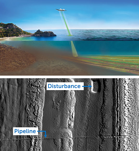
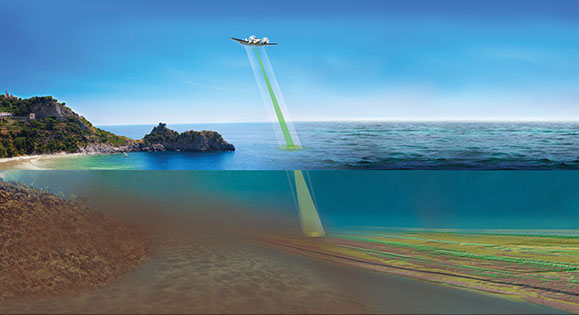
Top: Teledyne airborne lidar conducting an underwater surveillance operation. Bottom: High-resolution 3D seabed map below 35 meters of water, revealing excavation disturbances and a submerged pipeline. (Images credit: Teledyne Geospatial)
Teledyne Geospatial is committed to supporting key missions for maritime safety, such as object and change detection around critical underwater infrastructure (CUI), with solutions that deliver rapid data intelligence. Alongside Teledyne Marine and Teledyne FLIR, Teledyne Geospatial will demonstrate a rapid method for underwater surveillance. This involves deploying an airplane equipped with airborne lidar that provides high-speed, high-resolution underwater surveillance that is 45 times faster than traditional methods and is delivered through CARIS software. This method is the fastest way to sweep for underwater objects and disturbances before deploying vessels in smaller targeted areas, supporting SeaSEC’s mandate for the detection, classification, and localization of objects around critical underwater infrastructure.
Teledyne Geospatial will leverage its teams from offices in both Canada and the Netherlands at the event, participating in challenges for seabed mapping, situational awareness, and object detection.